Visualize Projects,Drive Impact
Transform your project data into powerful insights with AI-driven heatmaps, intelligent reporting, and seamless geographic visualization. Built for government agencies and development organizations.
Powerful Features forModern Project Management
Everything you need to visualize, analyze, and manage your development projects with cutting-edge technology and intuitive design.
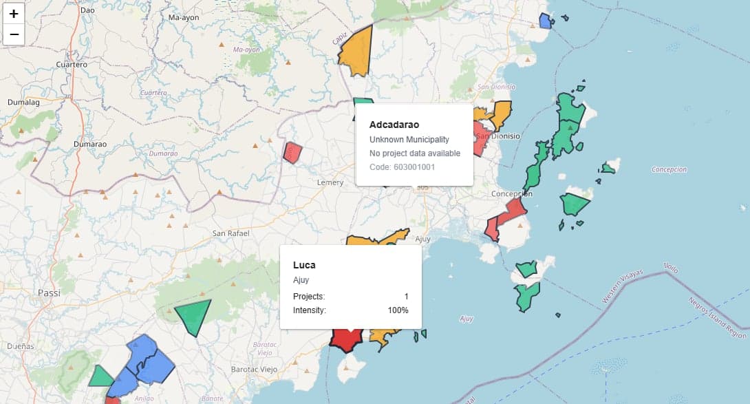
Interactive Heatmaps
Visualize project intensity, costs, and development patterns across geographic regions with dynamic color-coded maps.
AI-Powered Assistant
Chat with your data using natural language. Generate reports, create charts, and get insights instantly.
Advanced Analytics
Comprehensive reporting with customizable charts, trend analysis, and performance metrics.
Smart Import
Upload Excel files and let AI automatically extract and organize project data with intelligent matching.
Dynamic Reports
Generate professional reports with charts, statistics, and AI-powered analysis in seconds.
Secure & Reliable
Enterprise-grade security with role-based access control and audit trails for government compliance.
Measurable Impact
Organizations using GeoTraizer report significant improvements in efficiency and decision-making speed.
Faster Decision Making
Reduce time spent on data analysis
Better Collaboration
Improved team coordination
Increased Efficiency
Boost in project planning speed
See GeoTraizer inAction
Experience the power of intelligent project visualization and management through our interactive platform demonstrations.
Interactive Heatmaps
Visualize project density, costs, and development patterns across regions with dynamic heat mapping.
Ready to Transform YourProject Management?
Join leading government agencies and development organizations already using GeoTraizer to make data-driven decisions.
Stay Updated
Get the latest features and updates delivered to your inbox.
No spam. Unsubscribe at any time.
Get in Touch
Have questions? Our team is here to help you get started.